!
Latest updates
Thailand Tourist Visas, Entry Rules and Visa Runs
Updated 11th Sep 2026
Frequent Flyer Programmes in Thailand: Which Is Worth Joining
Updated 10th Sep 2026
Andaman or Gulf: Five Thai Coasts, When to Go, and the Airport for Each
Updated 10th Sep 2026
Thailand Travel Tips: Riding, Rules and What to Carry
Updated 10th Sep 2026
Thai Phrases for the Airport: What to Say at a Counter or Gate
Updated 10th Sep 2026
The Beaches of Phuket
Updated 27th Aug 2026
This page covers Phuket's best-known beaches, on the island's west and south coasts, working down from the airport end in the north to the southern tip. Each entry gives its position, its length where sources publish one, and what it is like. The swimming-safety section comes first, because between May and October it is the part that changes what you should do.
Swimming safety in the monsoon season (May to October)
The southwest monsoon runs from May to October and peaks around September, and it leaves the sea on Phuket's west-facing beaches rough. Patrolled beaches mark the water with flags. Phuket beach guides set the code out as red for do not enter, green for safe conditions, and a red flag flown together with a yellow one for a lifeguard-patrolled zone where swimming is permitted inside the flags and nowhere else.
A red flag means stay out of the water. Lifeguards fly it when the surf and the rip currents are dangerous, and people have drowned at Karon with the red flags up.
If a current pulls you out, do not swim against it. Swim parallel to the shore until you are clear of it, and if you cannot, float and signal for help. A rip current pulls you out, not under.
Phuket's lifeguards work under the co-ordination of the Phuket provincial office of Thailand's Department of Disaster Prevention and Mitigation (DDPM), according to a Thaiger report on the 2024 monsoon surf.
Current guides list Patong, Karon, Kata Yai, Kata Noi, Nai Harn, Surin, Bang Tao and Kamala as lifeguarded, roughly 08:00 to 18:00, with limited cover at Rawai. Laem Sing, Freedom and Yanui are small coves with no lifeguards at all.
In the nine days from 9 to 17 June 2024, monsoon surf killed four people at Nai Harn, Mai Khao and Surin. Lifeguards separately pulled eight tourists out of dangerous water at Karon and Patong in the same window.
Karon - repeated drownings even with red flags flying
A Karon Police officer described three drownings at Karon in 18 days, at least two of them with the red flags flying.
A year later, in June 2025, three tourists from Albania, Russia and Japan drowned at Karon within 18 days. A Karon Police officer, Lieutenant Colonel Charas Lempan, confirmed in a Thai Examiner report of 30 June 2025 that the flags were up and the sea visibly rough in the cases he described. The same report puts rip currents at Karon at up to 2.5 metres per second, which is faster than an Olympic swimmer.
The beaches at a glance
| Beach | Where it is | What it is known for |
|---|---|---|
| Mai Khao | Northwest coast, beside the airport | The island's longest beach, about 11 km, inside Sirinat National Park, with no development on the sand itself |
| Bang Tao | West coast, roughly halfway between the airport and Patong | Reported at 6 to 8 km, and the multi-resort Laguna complex |
| Surin | West coast, between Bang Tao and Laem Sing | About 800 m, beachfront vendors cleared, development behind it |
| Laem Sing | West coast, between Surin and Kamala | A cove of about 300 m, reached by boat or on foot over the rocks |
| Kamala | West coast, between Surin and Patong | Fishing-village character with hotels, shops and water-sports rental |
| Patong | West coast | About 3 km, the busiest and most developed beach on the island |
| Karon | Southwest coast | Reported at 3 to 4 km of pale quartz sand, and a documented monsoon drowning record |
| Kata Yai and Kata Noi | Southwest coast, about 20 km from Phuket Town | One bay split by a headland, Kata Noi the smaller and quieter half |
| Nai Harn | Southwest tip | Sheltered on three sides by hills, with a freshwater lagoon behind the sand |
| Rawai | Southern tip, about 17 km from Phuket Town | Longtail boats to the nearby islands, and swimming conditions that vary with the tide |
Mai Khao - the beach beside the airport
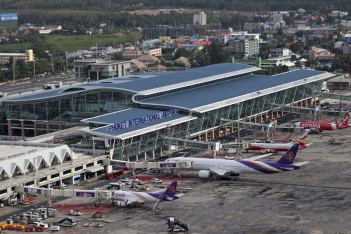
Sirinat National Park runs the length of Mai Khao, on the northwest coast, and the road into the park is the airport road. Mai Khao is about 11 km long, which makes it the longest beach on Phuket, and it is directly beside Phuket International Airport (HKT).
There is no development on the beach itself: no jet-skis, no parasailing, no sunbeds and no vendors. Sirinat charges an entrance fee, and its opening hours are reported as 08:00 to 16:30 daily.
The park was established in 1981 and given its present name in 1992. Leatherback and hawksbill turtles nest along this beach between November and February.
Bang Tao - the Laguna resort strip
Bang Tao is on the west coast, roughly halfway between the airport and Patong and immediately north of Surin. Sources report it at 6 to 8 km long, with no official measurement to settle on, which makes it Phuket's second-longest beach after Mai Khao. The sea floor shelves gently and the water is generally calm outside the monsoon.
The Laguna name here covers a multi-resort complex rather than a single property: SAii Laguna Phuket, Angsana Laguna Phuket, Dusit Thani Laguna Phuket and Banyan Tree Phuket are current brands inside it. A booking made on the Laguna name alone therefore does not tell you which property you are staying in.
Surin - vendors cleared, the area still developing
Phuket authorities cleared Surin's beachfront vendors and beach clubs twice, in 2016 and again in May 2025, which is why the sand itself now looks more natural than it has for several years. The beach runs about 800 m, on the west coast between Bang Tao and Laem Sing.
The area behind the beach is developed, and a large viewing platform called the Glass Terrace has been going up at its northern end since late 2023. Surin is one of the three beaches named in the June 2024 report above.
Laem Sing - a cove reached by boat, not by road
Laem Sing is a cove of about 300 m between Surin and Kamala, backed by granite boulders and palm trees. Current reporting says there has been no road access since a land dispute in April 2017, and that it is now reached by a short boat trip or a walk of roughly 15 minutes over the rocks from Surin.
Since Surin's beachfront vendors were cleared in 2025 the boat has been harder to find: look for it near the southern end of Surin. It was reported still running as of January 2026.
Kamala - a fishing village with hotels now
Kamala is on the west coast, with Surin and Laem Sing to the north and Patong to the south. It keeps a fishing-village character, but hotels, bungalows, restaurants, shops, water-sports rental and yoga studios are all present. The monsoon warnings above apply to Kamala as they do to the rest of the west coast.
Patong - the busiest beach on the island
Patong is a crescent bay of about 3 km on the west coast, and it is the busiest and most developed beach on Phuket. Mass tourism started here in the late 1970s, and the beach now carries the full range of hotels, restaurants, shops and nightlife, including Bangla Road. Water sports are widely available along the sand.
Patong sees routine red-flag closures in the wet season, and it is one of the two beaches where lifeguards pulled eight tourists from dangerous water in June 2024.
Karon - Phuket's pale quartz-sand beach
Karon's sand is pale, fine and quartz-rich. The beach is on the southwest coast and is commonly given as 3 to 4 km long.
Karon's monsoon record is set out under Swimming safety above, and it is worth reading before choosing this beach between May and October.
Kata Yai and Kata Noi - one bay, two beaches
Kata Yai and Kata Noi are one bay divided by a headland, about 20 km from Phuket Town according to the official Phuket provincial site. Kata Yai, the northern part, is the wider and busier at about 1.5 km, and the more family-oriented. Kata Noi, the southern cove, is the smaller and quieter at about 700 m.
Both shelve gently and the water is clear, and the provincial site calls Kata suitable for swimming and a place for diving lessons. Current sources describe Kata Noi as one of the safer swimming beaches on the island outside the monsoon, and that description is for the dry months only.
Nai Harn - a sheltered bay behind a lagoon
Nai Harn is at the southwest tip of the island, a bay sheltered on three sides by hills, with a freshwater lagoon immediately behind the beach. The hills reduce the wave action, and Nai Harn is reported to stay swimmable further into the wet season than most of the west-coast alternatives.
That does not carry through the whole season: Nai Harn is one of the three beaches where a fatal drowning happened in the nine days from 9 to 17 June 2024, so the red flags here should be read the same way as anywhere else on this coast.
Rawai - the boat-trip beach
Rawai is the main departure point for longtail boats to the nearby islands: Coral Island (Koh Hae), Racha, Koh Bon and Koh Lone. It sits at the southern tip of the island, about 17 km from Phuket Town on the provincial government's own figures.
Accounts of the swimming here do not agree. The Phuket provincial site describes the sea as shallow, with no current, and the beach as suitable for swimming. Other current sources describe a rocky shoreline, mudflats exposed at low tide and moored longtail boats, and advise against swimming.
What both descriptions support is that conditions vary with the tide and with the boat traffic, so this is a beach to look at before committing to a swim.